Publications
Reconstructing regional subsurface thermal structure of the Okavango rift zone, northern Botswana, and its low enthalpy geothermal potential
Authors: Izzul Qudsi, Daffa Arrofi, Luis Sebastian Gallegos, Ahmed Salem
11 November 2025
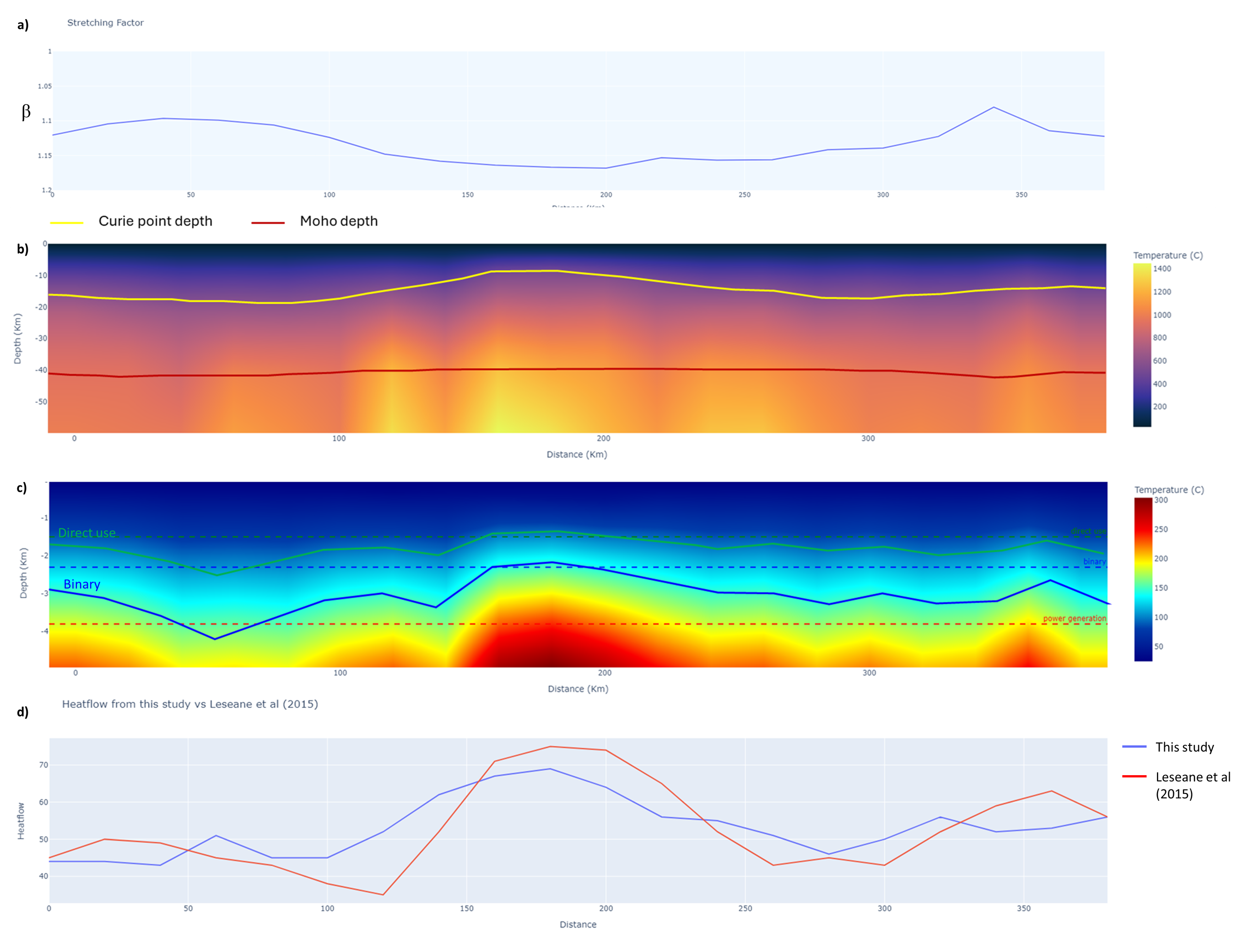
Previous studies identified the potential of the geothermal area within the Okavango rift zone in Northern Botswana due to the southward extension of The Eastern African Rift System (EARS). Although surface heat flow has been estimated in the area, including radiogenic heat production in the upper crust improves the accuracy of the calculations. The presence of moderate surface heat flow suggests that low-enthalpy geothermal resources could be used for direct-use applications such as heating, agriculture, and other sustainable energy solutions. This study evaluates geothermal potential in the Okavango Rift Zone by estimating the depth of the required temperature threshold using a constrained heat flow model. Regional thermal structures were modeled using constrains including Curie Point Depth, Moho depth, thermal conductivity of the layers, and radiogenic heat production, were constructed to achieve the goals. We iteratively adjusted the surface heat flow to determine the best fit of the model by comparing the temperature at CPD and Moho with reference values and predictions from the cooling plate model. The model proposed in this study minimized the surface heat flow estimation error, matching wellbore values within ± 2 mW/m2. Based on our results, Maun City possibly has the potential for direct use or binary geothermal applications with a depth of <1.4 km and 2.3 km, respectively. Integrating radiogenic heat production into the geotherm model, improves the surface heat flow estimation and provides a robust methodology applicable to other geothermal fields with similar tectonic systems.
Read More...Leveraging generative AI and hyperspectral drill-core imaging for fully automated mineral mapping of unconventional reservoir
Authors: Izzul Qudsi, Hilary Corlett, Ardiansyah Koeshidayatullah
11 October 2025
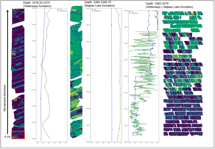
The acquisition of hyperspectral imagery on core samples significantly enhances the ability of geoscientists to conduct preliminary reservoir characterization particularly for unconventional exploration. Hyperspectral analysis is particularly powerful in providing qualitative and quantitative mineral distribution maps on geological samples. Information about mineral distribution on unconventional shale cores (e.g., clay-dominated vs calcite-dominated) may aid in determining zones of sweet spots for hydraulic fracturing. Conventionally, the mapping of mineralogy in hyperspectral imagery requires considerable human involvement, ranging from the extraction of mineral endmembers, process of defining the representative reflectance spectra signature of every minerals in the hyperspectral dataset, to the selection of parameters for classification algorithms. We used a generative deep learning approach with modified Deep Embedded Clustering (DEC) and variational autoencoders (VAE) to automate mineral classification in hyperspectral imagery of Devonian unconventional reservoir cores from the Western Canada Sedimentary Basin. The cores are characterized by nodular carbonates and Si- and clay-rich shales with interbedded detrital carbonates, covering the upper portion of the Waterways Formation, the entire Majeau Lake and Duvernay formations, and a portion of the lower Ireton Formation. Our study demonstrates that the proposed generative AI approach is effective in qualitatively and quantitatively identifying key mineral endmembers, including calcite, non-clay silica-rich minerals, and clay minerals (illite and muscovite) and their mixtures. In addition, the algorithm is also able to extract and identify the spectral variation of the silica-rich minerals based on its organic content. The VAE + DEC algorithm was able to capture not only the thin interbedded layers but also its complex mineralogy that aligns well with findings from previous research on the studied formations. In addition, the spatial distribution of organic content variation is also identified correctly and matched with the laboratory measurements. Therefore, the proposed workflow emerges as a promising, less labor-intensive alternative for lithological mapping and brief rock properties analysis from hyperspectral datasets, offering potential further applications in unconventional reservoir drill core data.
Read More...Building a Web-Repository for PIT HAGI Proceedings: A Data-Driven Approach to Enhance Research Accessibility and Visualization
Authors: Mordekhai, Praviandy Gustandika, Oddy Anggadi Pranidhana
01 July 2025
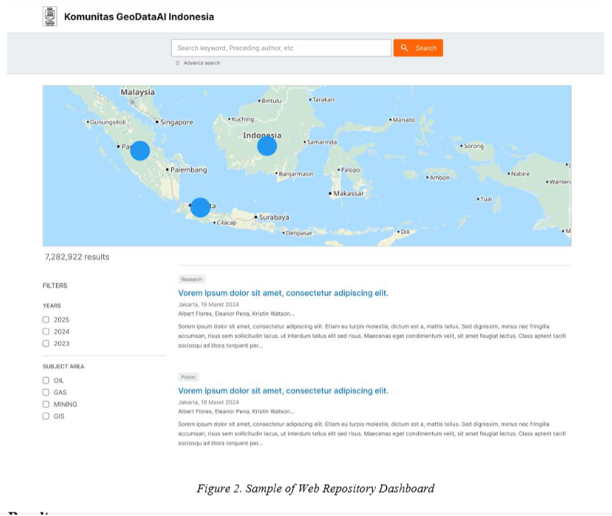
This paper presents the development of a comprehensive web-repository for storing and accessing published papers from PIT HAGI proceedings. The repository is structured using an SQL database to efficiently store key data points, including abstracts, keywords, authors, and titles. Raw data is initially stored in a data lake, ensuring scalability and flexibility. To enable effective categorization, topic modeling is applied to build a unified ground truth model that automatically classifies and organizes each proceeding. Additionally, extracted text data, which includes information on locations and basins, is used to enrich the repository with geospatial visualizations. These visualizations, embedded within the data repository, allow for dynamic GIS-based exploration of geographical and basin-related trends in the research. The extracted topics also provide insights into emerging trends in the proceedings, facilitating a more detailed examination of incoming papers. This data-driven approach aims to streamline the management and accessibility of scientific information, offering a valuable resource for trend analysis and future research in geoscience.
Read More...Mineral identification on hyperspectral imagery of rock samples using machine learning
Authors: Izzul Qudsi, Afnindar Fakhrurrozi, Mordekhai, Praviandy Gustandika, Muhammad Rifat Noor
05 June 2024
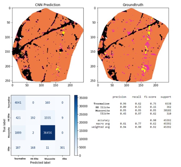
Mineralogy plays an important role in the early stages of earth resource exploration. In the past decades, geologists started to use hyperspectral in various scales of mineral identification, from hand specimen samples to airborne geological mapping surveys. Performing conventional mineral classification with hyperspectral methods is time-consuming and requires significant human intervention, from the endmember selection for each mineral to validating the classes manually in laboratory analysis. In this study, we introduced supervised machine learning algorithms to stimulate the mineral mapping process of a large dataset of core data. Three hyperspectral imageries of milled pebbled samples were used where one of the samples was pre-identified and used for training machine learning models to identify the mineralogy of the other two samples. The samples contain four minerals; namely Muscovite, Tourmaline, Illite and High-Crystallinity Illite, that will be auto-identified by the machine learning algorithms. In this study, Random Forest and Convolutional Neural Network were the selected algorithms to perform the mineral identification. Both algorithms produce high-accuracy mineral maps compared to the existing mineral maps from the previous study. The Convolutional Neural Network struggled to identify High-Crystallinity Illite, whilst Random Forest succeeded in separating High-Crystallinity Illite from other minerals. Thus, the Random Forest algorithm produces higher accuracy results. The proposed workflow provides a time-efficient alternative methodology for further mineral mapping process on a larger scale dataset.
Read More...3D shear wave velocity imaging of the subsurface structure of granite rocks in the arid climate of Pan de Azúcar, Chile, revealed by Bayesian inversion of HVSR curves
Authors: Rahmantara Trichandi, Klaus Bauer, Trond Ryberg, Benjamin Heit, Jaime Araya Vargas, Friedhelm von Blanckenburg, Charlotte M Krawczyk
15 May 2024
Seismic methods are emerging as efficient tools for imaging the subsurface to investigate the weathering zone. The structure of the weathering zone can be identified by differing shear wave velocities as various weathering processes will alter the properties of rocks. Currently, 3D subsurface modelling of the weathering zone is gaining increasing importance as results allow the identification of the weathering imprint in the subsurface not only from top to bottom but also in three dimensions. We investigated the 3D weathering structure of monzogranite bedrock near the Pan de Azúcar National Park (Atacama Desert, northern Chile), where the weathering is weak due to the arid climate conditions. We set up an array measurement that records seismic ambient noise, which we used to extract the horizontal-to-vertical spectral ratio (HVSR) curves. The curves were then used to invert for 1D shear wave velocity (_V_s) models, which we then used to compile a pseudo-3D model of the subsurface structure in our study area. To invert the 1D _V_s model, we applied a transdimensional hierarchical Bayesian inversion scheme, allowing us to invert the HVSR curve with minimal prior information. The resulting 3D model allowed us to image the granite gradient from the surface down to ca. 50 m depth and confirmed the presence of dikes of mafic composition intruding the granite. We identified three main zones of fractured granite, altered granite, and the granite bedrock in addition to the mafic dikes with relatively higher _V_s. The fractured granite layer was identified with _V_s of 1.4 km s−1 at 30–40 m depth, while the granite bedrock was delineated with _V_s of 2.5 km s−1 and a depth range between 10 and 50 m depth. We compared the resulting subsurface structure to other sites in the Chilean coastal cordillera located in various climatic conditions and found that the weathering depth and structure at a given location depend on a complex interaction between surface processes such as precipitation rate, tectonic uplift and fracturing, and erosion. Moreover, these local geological features such as the intrusion of mafic dikes can create significant spatial variations to the weathering structure and therefore emphasize the importance of 3D imaging of the weathering structure. The imaged structure of the subsurface in Pan de Azúcar provides the unique opportunity to image the heterogeneities of a rock preconditioned for weathering but one that has never experienced extensive weathering given the absence of precipitation.
Read More...